Unesco description
Macquarie Island (34 km long x 5 km wide) is an oceanic island in the Southern Ocean, lying 1,500 km south-east of Tasmania and approximately halfway between Australia and the Antarctic continent. The island is the exposed crest of the undersea Macquarie Ridge, raised to its present position where the Indo-Australian tectonic plate meets the Pacific plate. It is a site of major geoconservation significance, being the only place on earth where rocks from the earth’s mantle (6 km below the ocean floor) are being actively exposed above sea-level. These unique exposures include excellent examples of pillow basalts and other extrusive rocks.
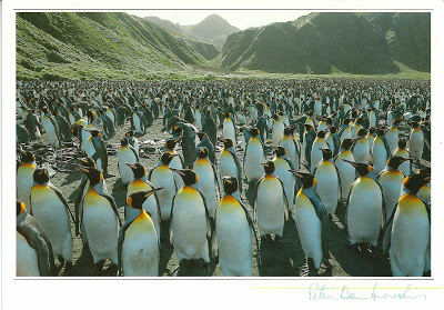
Received through a private swap on 16.10.2013
The Australian/Briton Frederick Hasselborough discovered the uninhabited island accidentally on 11 July 1810 when looking for new sealing grounds. He claimed Macquarie Island for Britain and annexed it to the colony of New South Wales in 1810. The island took its name after Colonel Lachlan Macquarie, Governor of New South Wales from 1810 to 1821. Hasselborough reported a wreck “of ancient design”, which has given rise to speculation that the island may have been visited before by Polynesians or others.
Macquarie Island is an exposed portion of the Macquarie Ridge, and is located where the Australian plate meets the Pacific plate. It is the only place in the Pacific Ocean where rocks from the mantle are actively exposed at sea level.
